
 |  |  |
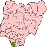
| Map of Bayelsa State | Executive Governor Henry Seriake Dickson | Coat of Arms |
| Official Website: http://www.bayelsa.gov.ng | ||
| Population: 1,703,358 (2006 Estimate) Alias: Pride of the Nation | ||
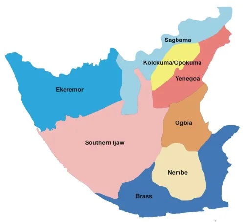
| Local Governments | ||
| Brass Ekeremor Kolokuma/Opokuma Nembe | Ogbia Sagbama Southern Jaw Yenegoa | |
 | GENERAL INFORMATION Bayelsa State was created on October 1, 1996 out of the old Rivers State by the then regime of General Sani Abacha. The name, Bayelsa, is an acronym of three former Local Government areas Brass, Yenagoa and Sagbama in the then Rivers State, which had earlier on comprised the entire area now constituting Bayelsa State. In the tradition in the old Rivers State, which is Bayelsa State was created from, acronyms are sued for local government areas. Brass Local Government Area was referred to as BALGA, for short; Yenagoa was simply YELGA, while Sagbama was SALGA. So in naming the new state, BALGA, YELGA, and SALGA was compounded to form BAYELSA. |
Located in the Southern part of Nigeria, Bayelsa covers 21,100 Square Kilometres with capital at Yenagoa .Bayelsa State is geographically located within Latitude 04o 15' North, 05 o 23' South and longitude 05 o 22' West and 06 o 45' East. It shares boundaries with Delta State on the North, Rivers State on the East and the Atlantic Ocean on the West and South.
Bayelsa State is a tropical rain forest, with more than three quarters of this area covered by water, with a moderately low land stretching from Ekeremor to Nembe. The area lies almost entirely below sea level with a maze of meandering creeks and mangrove swamps. The network of several creeks and rivers in the South, all flow into the Atlantic Ocean via the major rivers such as San Bartholomew, Brass, Nun, Ramos, Santa Barbara, St. Nicholas, Sangana, Fishtown, Ikebiri Creek, Middleton, Digatoro Creek, Pennington and Dobo. The vegetation here is characterized by the mangrove forest. In the North, it has a thick forest with arable lands for cultivation of various food and cash crops.
There are four main languages in Bayelsa State, which are Izon, Nembe, Ogbia and Epie-Atissa. The predominant religions in the State are Christianity and Traditional worship. Bayelsa State has 24 first class traditional rulers (and many second and third class traditional rulers) recognized by the State Government.
ECONOMY
The major occupations in the State are fishing, farming, palm oil milling, lumbering, palm wine tapping, local gin making, trading, carving and weaving.
Bayelsa State is a major oil and gas producing area and it contributes over 30% of Nigeria's oil production. Bayelsa State is home to Oloibiri in Ogbia Local Government Area, where oil was first struck in Nigeria in commercial quantities in 1956. Gas production activities are currently being intensified in the State as feedstock to the LNG Gas Supply Plants in Bonny which is located in Oluasiri local government area of the state. Also the gas feed will feed into the proposed national associated gas gathering networks that will feed other LNG plants, power plants and end users in the manufacturing sector. The major oil exploration and production companies operating in the State are Shell, Agip and ChevronTexaco.
The Kolo Creek Gas Turbine Project owned by the Bayelsa State Government supplies electricity to Yenagoa, the State Capital, and surrounding towns and villages. Bayelsa State is, presently, the only State in Nigeria that provides electricity for itself without any supply from the National Electricity Grid.
Bayelsa State has large reserves of clay, sand and gravel.
TOURISM
Bayelsa State has a wide variety of festivals, music, arts, crafts, folklore, artifacts, museums and monuments. The White Graveyard at Twon-Brass in Brass LGA, the Slave Tunnel at Akassa in Brass LGA, Olodi Museum at Ogbolomabiri, Mangrove Museum at Nembe, Ogidigan Deity at Bassambiri and King Ockiya's Mausoleum at Ogbolomabiri all in Nembe LGA, Late Chief Christopher Iwowari's Monument at Bassambiri in Nembe LGA. Bronze Heads at Opume in Ogbia LGA, Isaac Boro Memorial Monument at Kaiama in Kolokuma/Opokuma LGA.
These museums are stocked with artifacts dating back to hundreds of years. A proposed Museum at Oloibiri will chronicle the history of oil exploration in Nigeria and serve as a center of excellence in petroleum history, entertainment and learning.
At Twon-Brass in Brass Local Government Area, there are the Commonwealth Graves of British soldiers who died in the Nembe-British War of 1895 (otherwise know as the Akassa war). In nearby Akassa, there is the Slaves Transit Camp. There is a War Boat in Aleibiri. The Atlantic Ocean beache stretches across Twon-Brass, Okpoama, Olodiama, Koluama, Sangana.

TOURIST ATTRACTIONS
Akassa LighthouseAkassa Slave Transit Camp and Tunnel
Isaac Jasper Adaka Boro Monument
Oxbow Lake
Peace Park
White-Man Graveyard at Twon Brass
FESTIVALS AND CARNIVALS
Amasinghan Festival
Asi Oge Festival
Eremutoru Festival
Idumangi Festival
Idumangi Olali
Igboruma War Canoe
Ikpai-Kpai Annual Festival
Ikagi Masquerade
Izogua Annual Festival
Lake Ifi Fishing Festival
Obunem Festival
Odemimom Festival
Ogoriba Uge Festival
Oguberi Festival
Okolode Festival
Opuaduno Lake Fishing Festival
Uge Adiafa Festival
Seigbein Fishing Festival